Introduction: The Pursuit of Exceptional Photography in Iceland
Iceland, a land sculpted by fire and ice, offers a photographic canvas unlike any other on Earth. From the ethereal glow of the Northern Lights dancing above glacial lagoons to the raw power of its cascading waterfalls and the stark beauty of its volcanic landscapes, every corner presents exceptional opportunities for stunning imagery. For photographers, both amateur and seasoned professionals, the allure is undeniable. However, capturing these iconic and often remote scenes requires more than just a good camera; it demands meticulous planning, precise navigation, and an intimate understanding of the landscape's nuances. As you plan your 2026 Iceland adventure, a common dilemma arises: should you rely on readily available free travel apps, or is there a compelling reason to invest in a specialized photography tool? The market is saturated with free navigation and travel planning applications, making them an obvious first choice for many. Yet, the unique demands of photographic exploration in Iceland often expose the limitations of these general-purpose tools. This post aims to provide a comprehensive comparison, delving into why a dedicated **Iceland photography map vs free apps** is a crucial decision for anyone serious about maximizing their photographic success and overall travel experience in this majestic country. We’ll help you make an informed choice, ensuring your quest for the perfect shot is as efficient and rewarding as possible.The Appeal of Free Travel Apps: What They Offer for Iceland Photography
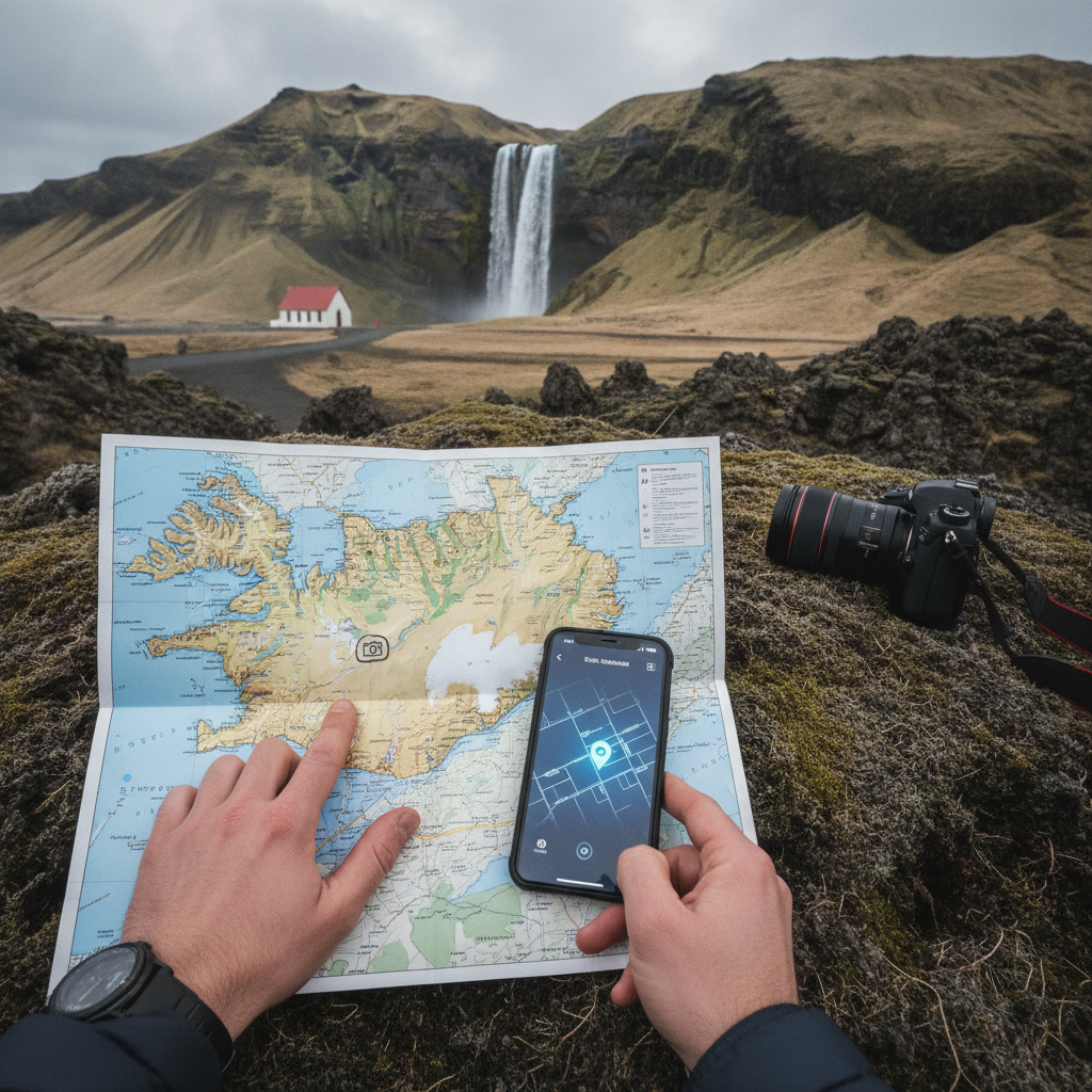
Free travel apps have revolutionized how we navigate and explore new destinations. Popular platforms like Google Maps, Maps.me, and Waze have become widely used tools for millions of travelers worldwide, and naturally, many photographers consider them for their Iceland trips. These apps offer a foundational level of utility that is undeniably convenient. Their general utility for basic navigation is solid. They can guide you to major towns, popular points of interest (POIs) like the Blue Lagoon or the Golden Circle attractions, and help you find essential services such as gas stations, restaurants, and accommodations. Many offer turn-by-turn directions, real-time traffic updates (where available), and even public transport information in more urbanized areas. For a casual tourist primarily focused on getting from A to B and seeing the most famous sights, these apps often suffice. They are easy to download, intuitive to use, and, crucially, cost nothing upfront. However, when it comes to the specialized needs of photography, the limitations of these free apps quickly become apparent. While they might pinpoint a waterfall, they rarely offer specific photographic details. You might find yourself arriving at a location only to discover the light is harsh, the best compositional angle is hidden, or the parking spot is miles from the actual viewpoint. They often direct you to the most crowded, obvious access points, which can be frustrating when you're seeking unique, uncluttered shots. Furthermore, the information provided is generic. A pin for "Skogafoss" tells you where the waterfall is, but not the optimal time for sunrise light hitting the spray, the best lens for a wide-angle shot from a specific vantage point, or whether a particular hiking trail leads to a less-frequented, higher viewpoint. For photographers, this lack of specific, actionable insight can lead to wasted time, missed opportunities, and ultimately, less compelling images. This is where the core difference between a generic navigation tool and a specialized **Iceland photography map vs free apps** truly emerges.Why a Dedicated Iceland Photography Map Excels: Precision, Detail, and Photographic Insight
When your objective is to capture high-quality images in Iceland, the advantages of a dedicated photography map become crucial. Unlike generic travel apps, these specialized tools are built from the ground up with the photographer's unique needs in mind, offering a level of precision, detail, and insight that free alternatives simply cannot match. This is where the **benefits of dedicated photography map Iceland** are clearly demonstrated. Firstly, dedicated maps feature curated locations specifically chosen for their photographic potential. This goes far beyond the most popular tourist spots. While iconic locations are included, a good photography map will also guide you to lesser-known gems, hidden viewpoints, and unique compositions that are often overlooked by general travel guides. These are the spots that allow your portfolio to stand out, offering a fresh perspective on Iceland's renowned beauty. Imagine discovering a secluded black sand beach or a unique rock formation that isn't swarming with crowds – that's the kind of value a curated map provides. You can explore a vast array of these unique photographic locations directly on our site at Iceland Photo Map Locations. Secondly, and perhaps most critically, dedicated photography maps provide detailed photographic information for each location. This includes crucial insights such as the best times for light – precisely when the golden hour bathes a landscape in warm tones or the blue hour casts its ethereal glow. You'll find guidance on optimal shooting angles, composition tips to make the most of the scene, and even recommended gear or lens choices for specific shots. For instance, knowing whether a wide-angle lens is essential for a panoramic view of Dettifoss or if a telephoto is better for capturing details of a distant glacier can save valuable time and ensure you're prepared. This level of detail transforms a simple location pin into a comprehensive photographic guide. Thirdly, reliable offline access is not just a convenience but a necessity in Iceland. Much of the country's breathtaking beauty lies in its remote areas, where cellular service is often non-existent or patchy at best, as noted by Visit Iceland. Relying on an internet connection for navigation or photographic details can leave you stranded or, worse, missing out on crucial shooting opportunities. A dedicated photography map, designed for offline use, ensures you have all the information you need, regardless of connectivity. This peace of mind is invaluable when exploring the Highlands or the remote Westfjords. Finally, the best dedicated photography maps often integrate community insights and receive regular updates from experienced photographers. This means the information is not static; it evolves with seasonal changes, new discoveries, and practical tips from a community of users who share a passion for Iceland photography. This collaborative aspect ensures the map remains current, relevant, and packed with practical advice that only real-world experience can provide. When considering an **Iceland photography map vs free apps**, this depth of photographic expertise is a major differentiator.Beyond Basic Navigation: Specialized Features of the Best Paid Iceland Photography Apps
While free apps offer basic guidance, the **best paid Iceland photography app** takes your planning and execution to an entirely different level, moving far beyond simple navigation to provide a suite of specialized features tailored for the discerning photographer. These features are designed to mitigate common challenges, optimize your time, and enhance your creative output significantly. One of the most valuable features is the provision of exact GPS coordinates for precise parking and shooting spots. Generic apps might drop a pin on a general attraction, leaving you to guess where to park or how to access the best viewpoints. A dedicated photography map, however, will often provide multiple, highly accurate coordinates: one for the most convenient parking, another for a classic composition spot, and perhaps even a third for a challenging but rewarding hike to an elevated perspective. This eliminates frustrating guesswork and ensures you spend your time shooting, not searching. For example, knowing the precise coordinates for the less-crowded eastern viewpoint of Skogafoss, rather than just the main parking lot, can make all the difference. Integrated environmental data is another significant advantage. Imagine having real-time weather forecasts, crucial for Iceland's notoriously unpredictable climate, directly within your photography map. Beyond general forecasts, specialized apps might include aurora predictions, showing the likelihood and intensity of the Northern Lights based on solar activity and cloud cover maps. This allows you to plan your night shoots with greater accuracy, ensuring you're in the right place at the right time to witness and capture this spectacular phenomenon. For those interested in planning specific routes, our Iceland Photo Map Itinerary feature can integrate these elements for optimal planning. Seasonal considerations are also meticulously detailed. Iceland transforms dramatically with the seasons, and what's accessible or photographable in summer might be completely different in winter. A dedicated map will provide insights into:- Ice Caves: Best times for tours, accessibility, and safety warnings.
- Puffin Nesting Sites: When and where to find these charismatic birds (e.g., Dyrholaey in summer).
- Midnight Sun: Optimal times for endless golden hour light in the summer months.
- Road Conditions: Which F-roads are open or closed depending on the season, crucial for highland access.
Saving Time and Effort: How a Photography Map Optimizes Your Iceland Adventure
Time is often the most precious commodity on any photography trip, especially in a destination as vast and diverse as Iceland. Every minute spent searching for a location, figuring out parking, or waiting for the right light is a minute not spent capturing breathtaking images. A dedicated photography map is an investment in efficiency, designed to save you significant time and effort, thereby optimizing your entire Iceland adventure. One of the primary ways it achieves this is through efficient route planning tailored specifically for photographers. Instead of simply plotting the shortest distance between two points, a photography map understands that the journey itself can be part of the photographic experience. It might suggest routes that pass by scenic viewpoints, group together geographically close photographic hotspots, or even recommend a specific driving order to catch the best light at multiple locations throughout the day. This strategic planning maximizes your time at prime locations, ensuring you're not rushing or backtracking unnecessarily. For example, when planning a trip along the South Coast, a dedicated map can sequence your stops from Seljalandsfoss to Skogafoss, then to Dyrholaey and Reynisfjara, optimizing for both light and travel time. Furthermore, a dedicated map is an invaluable tool for avoiding crowded tourist traps and discovering unique, less-frequented photographic gems. While iconic spots are a must-see, the sheer volume of visitors can make capturing a pristine, uncluttered shot challenging. Photography maps often highlight alternative viewpoints, secret trails, or lesser-known locations that offer similar beauty with fewer crowds. This allows you to craft a truly unique visual narrative of your Iceland trip, rather than just replicating images seen countless times before. Imagine finding a secluded waterfall or a quiet stretch of black sand beach – these are the moments that elevate your photography. Iceland Photo Map's regional guides, such as the one for the Westfjords Remote, are perfect examples of how to discover such unique locations. The reduction in on-the-ground research time is another significant benefit. Without a dedicated map, you might spend hours each day poring over general travel guides, trying to cross-reference weather apps, and reading forum posts to piece together photographic information. A specialized map consolidates all this data into one intuitive platform. This allows you to focus more on shooting, experimenting with compositions, and truly experiencing the magic of Iceland, rather than being glued to your phone doing research. You arrive at each location with a clear understanding of what to expect, where to go, and how to best capture it. Finally, for those planning multi-day photography expeditions, a dedicated map streamlines logistics significantly. It can help you plan entire itineraries, identify suitable accommodations near prime shooting spots, and even suggest contingency plans for bad weather days. This comprehensive approach to trip planning ensures a smoother, more productive, and ultimately more enjoyable photographic journey through Iceland.Cost vs. Value: Evaluating the Investment in an Iceland Photography Map vs Free Apps
When considering an **Iceland photography map vs free apps**, the immediate perception is often that "free" is always better. However, a deeper evaluation reveals that the upfront cost of a dedicated photography map is a strategic investment that delivers substantial value, far outweighing the potential hidden costs and missed opportunities associated with relying solely on free alternatives. This is a critical factor **why buy Iceland photo map** for serious photographers. Let's compare the upfront cost of a dedicated map to the potential hidden costs of free apps. While free apps cost nothing to download, they can incur significant expenses in other ways. Imagine arriving at a stunning location only to realize you've missed the optimal light because your generic app didn't provide golden hour timings. That's a missed shot – an irreplaceable moment lost. Or perhaps you spend an hour driving down the wrong gravel road because the free app's directions were imprecise for a remote spot, wasting precious fuel and time. These inefficiencies accumulate, translating into tangible costs: extra fuel, extended car rental days, and the opportunity cost of not capturing the images you envisioned. The frustration of these setbacks also detracts from the overall travel experience. For serious photographers, repeat visitors, or those aiming for professional-grade results, the long-term value of a dedicated map is undeniable. A high-quality photography map is not just for one trip; it's a resource that can be leveraged for future visits, evolving with updates and community insights. It becomes a personal photographic atlas, continually enhancing your understanding of Iceland's diverse landscapes. The knowledge and efficiency gained from using such a tool directly contribute to the quality of your output, potentially leading to portfolio-worthy images, licensing opportunities, or simply a deeper personal satisfaction with your work. Consider the overall investment in an Iceland trip. Flights, accommodation, car rental, food, and gear can easily amount to thousands of dollars. Relative to this substantial investment, the cost of a dedicated photography map is a small fraction, yet it profoundly enhances the return on that investment by maximizing your photographic success. It's akin to buying quality lenses for your camera – an upfront cost that directly improves the quality of your final product. Ultimately, the peace of mind and confidence gained from having expert-curated information at your fingertips are invaluable. Knowing that you're heading to the best spots, at the best times, with all the necessary details, allows you to relax and fully immerse yourself in the creative process. It reduces stress, minimizes uncertainty, and empowers you to make informed decisions on the fly. This confidence translates into better photographs and a more enjoyable, less stressful journey. When you weigh these factors, the argument for investing in a dedicated **Iceland photography map vs free apps** becomes clearly evident.Real-World Scenarios: When to Use a Dedicated Map and When Free Apps Suffice
Understanding the distinct strengths of both free travel apps and dedicated photography maps is key to making the most of your Iceland adventure. While a dedicated map offers unparalleled advantages for photographic pursuits, free apps still hold their own for general logistics. The optimal approach often involves a smart hybrid strategy. Let's consider scenarios where free apps often fall short for photographers:- Finding Specific Compositions: Imagine you want to capture the iconic perspective of Kirkjufell with Kirkjufellsfoss in the foreground. A free app might get you to the general area of Kirkjufell, but it won't guide you to the precise parking spot for the waterfall, nor will it tell you the best angle to align the mountain and waterfall for that classic shot, or when the light will be optimal. You'd likely spend valuable time scouting, potentially missing the window of perfect light.
- Navigating F-Roads: Many of Iceland's most spectacular photographic locations, especially in the Highlands, are accessed via F-roads, which legally require a 4x4 vehicle to traverse safely and responsibly. The Icelandic Road and Coastal Administration explicitly states that F-roads are only suitable for 4x4 vehicles and off-road driving is strictly forbidden. Free apps often struggle with the nuances of these roads – their seasonal closures, specific river crossings, or treacherous conditions. A dedicated map, however, will typically have detailed F-road information, including warnings, accessibility status, and precise routes to remote spots like Aldeyjarfoss or Landmannalaugar.
- Understanding Light Conditions at a Specific Waterfall: You're at Seljalandsfoss and want to photograph behind the waterfall. A free app won't tell you the best time of day to avoid harsh shadows, when rainbows might appear in the spray, or the optimal lens to use for a wide-angle shot from a specific vantage point from behind the cascade. A photography map would provide these details, ensuring you capture the waterfall at its most photogenic. For more insights on waterfalls, check our Iceland Waterfall Map.
- This allows for precise planning, maximizing your chances of capturing the Northern Lights.
- Accessing Remote Highlands: For ambitious trips into the heart of Iceland, such as to the Askja caldera or Kverkfjoll ice cave, a dedicated map is indispensable. It provides detailed topographical information, precise GPS tracks, safety warnings for glacial rivers, and knowledge of emergency shelters – information often absent from generic apps.
- Identifying Bird Nesting Sites: If your interest lies in wildlife photography, finding specific bird nesting sites for puffins, arctic terns, or other species requires specialized knowledge. A dedicated map can pinpoint these sensitive areas, often with information on the best viewing distances and times, ensuring both successful photography and minimal disturbance to wildlife.
Conclusion: Making the Right Choice for Your Iceland Photography Journey
Iceland is a destination offering immense photographic potential, a land of immense beauty and numerous photographic opportunities. Yet, transforming those opportunities into truly exceptional images requires more than just a camera and a sense of adventure; it demands precision, insight, and reliable guidance. As we've explored the distinct advantages of a dedicated **Iceland photography map vs free apps**, the choice for serious photographers becomes clear. Free travel apps offer convenience for basic navigation and general travel logistics, serving as useful tools for finding towns, restaurants, and common tourist attractions. However, their generic nature and lack of specialized photographic detail make them inherently limited for anyone aspiring to capture the distinctive character of Iceland's landscapes. They often fall short in providing crucial information like optimal light conditions, precise shooting angles, accessibility details for remote locations, or critical safety warnings. In contrast, a dedicated Iceland photography map, like the one we offer, provides an invaluable resource. It's a meticulously curated guide, packed with expert knowledge on specific photographic locations, including hidden gems and less-frequented spots. It offers detailed photographic insights – from golden hour timings and compositional tips to recommended gear. Crucially, it provides reliable offline access, essential for Iceland's remote regions, and often integrates real-time environmental data like aurora forecasts and seasonal considerations. The investment in such a map transcends mere cost; it's an investment in saving time, avoiding frustration, ensuring safety, and ultimately, maximizing your chances of capturing the breathtaking images you envision. For photographers seeking to maximize their time, minimize guesswork, and capture truly exceptional images that stand apart, a dedicated Iceland photography map is not just a helpful accessory; it's an essential tool. It empowers you to navigate with confidence, plan with precision, and shoot with purpose, enhancing your Iceland adventure into a more successful photographic journey. Make the informed choice for your 2026 Iceland journey and unlock the full potential of this incredible destination.Frequently Asked Questions
Are free travel apps completely useless for photography in Iceland?
No, free travel apps are not completely useless. They are excellent for general navigation, finding gas stations, restaurants, and major towns. For basic logistics and everyday travel needs, they can be quite helpful. However, for specific photographic details like optimal light conditions, precise shooting angles, or navigating remote F-roads to specific viewpoints, they often lack the specialized information a photographer needs.
What kind of specific photographic details can a dedicated Iceland photography map provide?
A dedicated Iceland photography map provides a wealth of specific details tailored for photographers. This includes: best times for light (golden hour, blue hour, sunrise/sunset times), optimal shooting angles and compositional tips for specific locations, recommended gear or lens choices, exact GPS coordinates for parking and shooting spots, seasonal considerations (e.g., ice cave accessibility, puffin nesting seasons), safety warnings, and accessibility information for challenging terrain or F-roads.
Is an Iceland photography map a one-time purchase or a subscription?
This depends on the specific product. At Iceland Photo Map, we typically offer our comprehensive maps as a one-time purchase, providing you with lifetime access to the detailed information and ongoing updates. Some platforms might offer subscription models, but we believe in providing enduring value for your investment, allowing you to revisit and leverage the map for future trips or planning.
Can I use a dedicated photography map offline in remote areas of Iceland?
Yes, absolutely. Many of Iceland's most stunning photographic locations are in remote areas with limited or no cellular service. A dedicated map ensures you have all the navigation, location, and photographic details available on your device, even without an internet connection, providing peace of mind and uninterrupted planning.
How does a dedicated map help with planning for specific weather or aurora conditions?
Dedicated photography maps often integrate or link to specialized weather forecasts that are more granular than general apps, focusing on cloud cover and precipitation relevant to specific photographic locations. Crucially, many also incorporate aurora predictions, showing the likelihood and intensity of the Northern Lights based on solar activity, combined with local cloud cover maps. This allows photographers to plan night shoots with high precision, choosing the best locations and times to maximize their chances of capturing the aurora borealis.
Ready to elevate your Iceland photography? Explore the Iceland Photo Map and unlock the full potential of your photographic journey!