Introduction: The Photographer's Quest for Iceland's Beauty
Iceland, a land forged by fire and ice, stands as an unparalleled muse for photographers worldwide. Its dramatic landscapes—from glacial lagoons and black sand beaches to powerful waterfalls and vibrant geothermal areas—offer an endless canvas for truly epic imagery. The interplay of unique geological features with the island's famously dynamic light creates photographic opportunities that are both challenging and immensely rewarding. However, capturing these breathtaking scenes often requires venturing beyond the well-trodden paths. This is where the crucial skill of effective navigation comes into play. Without precise planning and the right tools, the quest for Iceland's beauty can quickly turn into a frustrating endeavor, costing valuable time and potentially missing those fleeting moments of perfect light.
This comprehensive guide is designed to equip you, the discerning photographer, with the knowledge and resources necessary for seamlessly **navigating Iceland photo spots**. We'll delve into the essential tools, meticulous planning strategies, critical safety considerations, and expert tips for uncovering those elusive, hidden gems that define an unforgettable Icelandic photography adventure.
The Lure of Iceland's Photo Spots: Why Navigation is Key
Iceland's allure for photographers lies not just in its iconic landmarks but equally in its vast, untamed wilderness. Many of the most stunning and unique photographic opportunities are found in remote, often challenging-to-access locations. The sheer scale and isolation of these areas mean that reliable navigation isn't merely a convenience; it's a fundamental requirement for a successful trip. Good navigation skills and tools directly translate into maximizing your precious photography time, allowing you to spend less effort searching and more time composing your shots. Conversely, poor navigation can lead to wasted hours, missed light, and significant frustration, diminishing the overall experience.
Moreover, Iceland's environment is characterized by its dynamic and often unpredictable nature. Weather conditions can shift dramatically within minutes, impacting visibility, road accessibility, and even the very landscape itself. Terrain can be rugged, unmarked, and deceptive, making precise location awareness absolutely crucial for both photographic success and personal safety. For photographers, who often chase specific light conditions or unique angles, knowing exactly how to reach a desired viewpoint, even in challenging conditions, is paramount. This is precisely why specialized resources like the
Iceland Photo Map exist. Our maps provide a curated, accurate, and seamless solution for **navigating Iceland photo spots**, ensuring you spend less time guessing and more time capturing.
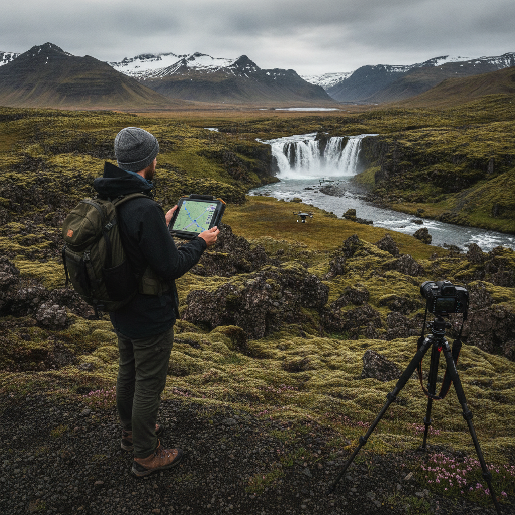
Successful navigation in Iceland demands a combination of robust tools and a solid understanding of how to use them effectively. Relying on a single method can leave you vulnerable, especially in areas with limited infrastructure.
GPS Devices & Apps
GPS technology is the cornerstone of modern navigation for photographers.
- Dedicated GPS Units: Devices like Garmin or Magellan offer superior ruggedness, longer battery life, and often better satellite reception in challenging terrain compared to smartphones. They are purpose-built for navigation, with physical buttons that are easier to operate with gloves on, and screens designed for outdoor visibility. Their primary downside is the upfront cost and the need to pre-load maps, which can sometimes be less detailed than online alternatives.
- Smartphone Apps: Your smartphone, when properly equipped, can be an incredibly powerful navigation tool. Google Maps: While excellent for general road navigation and finding points of interest, its offline map functionality, though useful, is often noted by users as less comprehensive for detailed off-road or remote area navigation compared to specialized apps. Maps.me: Known for its community-driven, offline map data, Maps.me is often praised for its detailed coverage of walking trails, smaller roads, and points of interest that might not appear on mainstream maps, making it a valuable tool for off-the-beaten-path exploration. It’s highly recommended for its detailed offline maps, which are crucial given Iceland's patchy cell service. Gaia GPS / AllTrails: These apps are geared more towards hiking and outdoor recreation, offering detailed topographic maps, elevation profiles, and track recording. They are invaluable for understanding terrain when planning to venture beyond established roads. The main limitations of smartphone apps are battery drain (especially in cold weather), screen glare, and the reliance on cellular data for real-time updates unless maps are downloaded. often carry a power bank.
Offline Maps
This cannot be stressed enough: **always download offline maps for your chosen region before you leave Wi-Fi coverage.** Cell service outside of major towns and along the Ring Road can be sporadic or non-existent. Having detailed offline maps for your GPS device or smartphone apps (Maps.me, Google Maps, Gaia GPS, etc.) ensures you can navigate even without a signal. This is critical for safety and efficiency, preventing you from getting lost or wasting time trying to load maps.
Satellite Imagery
Tools like Google Earth are invaluable for pre-scouting locations. Before you even set foot in Iceland, you can virtually explore areas, identify potential viewpoints, understand the surrounding terrain, and even spot challenging access points. This allows you to:
- Visualize the landscape from different angles.
- Identify ideal parking spots or trailheads.
- Anticipate potential obstacles like rivers, cliffs, or dense lava fields.
- Pinpoint exact spots for specific compositions, which you can then save as **GPS coordinates Iceland photography** points.
Iceland Photo Map
For photographers, generic maps often fall short. This is where specialized resources like
Iceland Photo Map become indispensable. Our maps are specifically curated for photographers, offering:
- Verified Locations: Hand-picked and validated photo spots, often with optimal viewpoints identified.
- Accurate GPS Coordinates: Precision coordinates that take you directly to the best angles, not just a general area.
- Detailed Information: Insights into accessibility, required vehicle types, best times to visit, and unique photographic features.
- Offline Usability: Designed for easy integration with your preferred offline navigation tools.
By using a dedicated photography map, you bypass the guesswork and gain immediate access to expert-level insights, significantly enhancing your efficiency and success rate.
Understanding Iceland's Road Conditions and Accessibility for Photographers
**Iceland road conditions for photographers** are a critical factor that can make or break a trip. The country's infrastructure, while generally good on main routes, presents unique challenges, especially when venturing into the highlands or remote areas.
F-Roads and 4x4 Vehicles
F-roads (mountain roads) are unpaved, often rough, gravel tracks typically found in the Icelandic highlands. They are designated with an "F" prefix (e.g., F208) and are legally only accessible by 4x4 vehicles. Attempting to drive a 2WD vehicle on an F-road is illegal, voids your rental car insurance, and can lead to significant fines and damage. For official information on F-road regulations, opening dates, and current conditions, always consult
Vegagerðin (the Icelandic Road and Coastal Administration).
- When They're Open: F-roads are generally only open during the summer months, typically from late June or early July to late September, depending on snowmelt and weather conditions. They close for winter due to snow and impassable conditions.
- Why a 4x4 is Mandatory: Beyond legal requirements, 4x4 vehicles offer higher ground clearance, better traction, and the ability to cross unbridged rivers (which can be challenging and require specific driving skills). Many breathtaking photo spots, especially in the interior, are only reachable via F-roads.
Gravel Roads and Potholes
Even outside of F-roads, many secondary roads in Iceland are unpaved gravel. These can be surprisingly rough, with loose stones, washboards, and significant potholes.
- Driving Tips: Drive slower on gravel roads to maintain control and avoid damaging your vehicle. Keep a safe distance from other cars to prevent stone chips. Be aware of dust, which can impair visibility.
- Tire Care: Check tire pressure regularly, and be prepared for potential punctures, especially if you're venturing far from services.
Weather Impact
Iceland's weather is notoriously fickle and can drastically alter road conditions.
- Snow and Ice: Even in shoulder seasons, snow and ice can make roads treacherous, particularly in higher elevations or shaded areas. Winter driving requires studded tires (often standard on rentals in winter) and extreme caution.
- Wind: Powerful winds are common and can make driving difficult, especially for smaller vehicles. They can also cause dust storms on gravel roads or snow drifts in winter.
- Rain: Heavy rain can reduce visibility, create slick conditions, and swell unbridged rivers on F-roads.
- Fog: Coastal and mountain areas frequently experience dense fog, which can appear suddenly and make navigation extremely challenging.
Real-time Information
Always check official sources for up-to-date road information before heading out.
- Vegagerðin (Icelandic Road and Coastal Administration): This is the definitive source for current road conditions, closures, and weather warnings. Their map provides color-coded road status, F-road opening dates, and live webcams. It's an indispensable tool for any driver in Iceland.
- Icelandic Met Office: Provides detailed weather forecasts, including wind speeds, precipitation, and aurora forecasts, which are crucial for planning your photography and ensuring travel safety.
Never underestimate the importance of these resources. Ignoring warnings can lead to dangerous situations and costly rescues.
Planning Your Photography Route: From Discovery to Destination
Effective route planning is the bedrock of a successful Icelandic photography trip. It’s an iterative process that blends inspiration with practical logistics.
Researching Locations
The journey begins with discovery.
- Inspiration: Start by browsing photography blogs, social media, and travel guides. Look for images that captivate you and note down the locations.
- Initial Coordinates: Once you have a list of desired spots, use tools like Google Earth or dedicated photography maps (like ours!) to find initial GPS coordinates. This is often the first step in pinpointing where you want to go. Explore our locations page for inspiration and starting points.
- Specific Interests: If you have a passion for a particular subject, such as waterfalls or lighthouses, focus your research. For example, you might look specifically at waterfalls in Iceland for your itinerary.
Timing is Everything
Photography is all about light, and Iceland offers unique lighting conditions.
- Golden Hour & Blue Hour: These magical times around sunrise and sunset are universally cherished by photographers. Plan your arrival at a location to coincide with these periods. In summer, golden hour can last for hours due to the high latitude.
- Midnight Sun (Summer): From May to August, daylight hours are incredibly long, with the sun barely dipping below the horizon. This offers extended golden hour opportunities but also means true darkness for aurora photography is limited.
- Aurora Borealis (Winter): To capture the Northern Lights, you need dark, clear skies, typically from September to April. Plan your evenings around aurora forecasts from the Icelandic Met Office and away from light pollution.
- Tides: For coastal locations like black sand beaches or sea stacks, tide times can dramatically affect compositions and accessibility. Check local tide charts.
- Seasonal Phenomena: Consider seasonal events like puffin nesting (May-August) or ice cave accessibility (winter only).
Creating Itineraries
Building a realistic and flexible itinerary is crucial.
- Group Locations Logically: Cluster photo spots that are geographically close to minimize driving time.
- Allocate Buffer Time: often add extra time for unexpected stops, changing weather, getting lost, or simply spending longer at a stunning location than planned. Rushing in Iceland is a recipe for frustration.
- Prioritize: If your time is limited, identify your absolute must-see spots and build your itinerary around them, allowing for flexibility for secondary locations.
- Flexibility: Iceland's weather can derail even the best-laid plans. Be prepared to adapt your route, swap days, or have alternative indoor activities planned.
Logistics
Don't overlook the practical aspects of your journey.
- Accommodation: Book well in advance, especially during peak season (June-August). Accommodation options can be sparse in remote areas.
- Fuel Stops: Plan your fuel stops carefully, particularly if venturing into the highlands or remote regions like the Westfjords. Distances between gas stations can be significant. often fill up when you have the chance.
- Food Availability: Similarly, grocery stores and restaurants are less frequent outside major towns. Pack snacks, water, and emergency food supplies, especially for longer days or remote excursions.
Mastering GPS Coordinates for Precision Photography in Iceland
For photographers in Iceland, GPS coordinates are not just navigational aids; they are the keys to unlocking specific, often hidden, viewpoints that transform a good photo into an exceptional one. Mastering their use is fundamental.
Understanding Coordinate Formats
GPS coordinates are typically expressed in a few common formats. It’s important to recognize them and know how to convert if necessary, as different devices or sources might use varying styles.
- Decimal Degrees (DD): This is perhaps the most common and easiest to use, representing latitude and longitude as decimal numbers (e.g., 64.1466° N, -21.9426° W). Many apps and online maps use this format.
- Degrees, Minutes, Seconds (DMS): A more traditional format that breaks down each degree into 60 minutes and each minute into 60 seconds (e.g., 64° 08' 47.8" N, 21° 56' 33.4" W). This format can appear more precise but is often less convenient for direct input into modern digital tools.
- Degrees Decimal Minutes (DDM): A hybrid format (e.g., 64° 08.796' N, 21° 56.56' W) that is common in marine navigation but less so for land-based photography.
Most modern GPS devices and apps can accept multiple formats or automatically convert them. If you encounter a format you're unfamiliar with, a quick online search for a "GPS coordinate converter" will provide numerous tools.
Inputting Coordinates
Entering coordinates accurately is crucial.
- Smartphone Apps: In apps like Google Maps or Maps.me, you can often paste or type coordinates directly into the search bar. Ensure you use the correct syntax (e.g., `latitude, longitude` with a comma and no spaces, or with the N/S/E/W indicators).
- Dedicated GPS Devices: These usually have a specific menu option to "Enter Coordinates" or "Add Waypoint." Follow the device's prompts carefully, paying attention to whether it expects decimal degrees or degrees/minutes/seconds, and inputting negative signs for west/south coordinates if applicable (or selecting W/S).
**Double-check your input.** A single misplaced digit can send you miles off course.
Accuracy Tips
Even with correct coordinates, getting to the exact spot can sometimes be tricky.
- Zoom In: Once you've navigated close to the coordinate, zoom in on your map to identify any specific features (e.g., a rock formation, a specific bend in a river, a designated parking area) that align with your photographic goal.
- Ground-Truthing: Compare what you see on your map/device with the actual landscape. Look for landmarks, elevation changes, or natural lines that match your pre-scouted satellite imagery.
- Multiple Waypoints: For complex locations, consider saving multiple waypoints: one for parking, one for the trailhead, and one for the optimal viewpoint.
Using Iceland Photo Map Coordinates
Our platform is designed to streamline this process. When you use
Iceland Photo Map's dataset, you're getting:
- Verified Precision: Our coordinates are meticulously verified to lead you to the exact, most photographically advantageous viewpoints. We've done the legwork of scouting and pinpointing the best angles.
- Ease of Use: The coordinates are presented in a universally compatible format, ready for direct input into most GPS devices and smartphone apps.
- Contextual Information: Alongside the coordinates, you'll find valuable context about accessibility, best times to visit, and unique features, further enhancing your ability to make the most of the location.
By leveraging our precise **GPS coordinates Iceland photography** becomes less about searching and more about shooting.
Finding Remote and Lesser-Known Photo Spots in Iceland
While the iconic locations are undeniably beautiful, the true magic of Icelandic photography often lies in discovering untouched landscapes and unique perspectives away from the crowds. This requires a blend of research, intuition, and responsible exploration.
Beyond the Golden Circle
The Golden Circle (Þingvellir, Geysir, Gullfoss) is fantastic for first-time visitors, but it barely scratches the surface of Iceland's photographic potential. To truly differentiate your portfolio, you need to venture further.
- The Westfjords: A remote and rugged peninsula known for its dramatic fjords, towering bird cliffs, and serene fishing villages. Far fewer tourists make it here, offering unparalleled solitude and raw beauty.
- The Highlands: Only accessible in summer via F-roads, the interior highlands are a vast wilderness of colorful rhyolite mountains (Landmannalaugar), black deserts, and powerful glacial rivers. This is where you find truly alien landscapes.
- East Fjords: Less visited than the south, the East Fjords offer a quieter charm with picturesque fishing villages, cascading waterfalls, and opportunities for reindeer spotting.
Local Insights and Resources
Leveraging local knowledge is an excellent way of **finding remote photo spots Iceland**.
- Talk to Locals: Engage with guesthouse owners, tour guides, or even local shopkeepers. They often have invaluable tips on hidden gems that aren't in guidebooks.
- Specialized Forums and Groups: Online photography communities focused on Iceland can be a goldmine of information, with experienced photographers sharing less-known spots.
- Iceland Photo Map: Our maps are designed not just for the famous spots but also to guide you towards unique and often less-traveled locations, expanding your photographic horizons.
Responsible Exploration
As you venture into remote areas, it's paramount to practice responsible tourism and photography. Iceland's nature is fragile, and it's our collective responsibility to protect it.
- Leave No Trace: Pack out everything you pack in. Do not leave any trash, food scraps, or other waste behind.
- Respect Private Property: Many beautiful spots are on or near private land. often be aware of signs and respect landowners' wishes. Ask for permission if unsure.
- Stay on Marked Paths: Off-road driving is strictly illegal in Iceland and causes irreparable damage to the delicate moss and vegetation. Stick to designated roads and trails. This is also for your safety, as the terrain can be deceptively dangerous. The Environmental Agency of Iceland (Umhverfisstofnun) provides clear guidelines on nature conservation and responsible travel.
- Protect Wildlife: Maintain a respectful distance from animals, especially nesting birds.
The Thrill of Discovery
The effort involved in **finding remote photo spots Iceland** is profoundly rewarding. There’s an unparalleled sense of accomplishment and wonder in standing before an untouched landscape, knowing you've found a unique perspective that few others have witnessed. These are the moments that truly define an Icelandic photography journey.
Safety First: Navigating Challenges and Emergencies in Iceland
Iceland's raw beauty comes with inherent risks. Prioritizing safety is not just advisable; it's absolutely essential for any photographer exploring the island, especially when venturing into remote areas.
Emergency Services
Knowing how to contact help is critical.
- Emergency Number: The universal emergency number in Iceland is **112**. This connects you to police, fire, and ambulance services.
- What to Provide: When calling 112, be prepared to give your exact location (GPS coordinates are invaluable here), the nature of the emergency, the number of people involved, and any specific injuries or dangers.
- SafeTravel App: The SafeTravel Iceland website and its associated app offer an emergency check-in service and a "112 Iceland" app that can send your GPS location to emergency services.
Weather Warnings
Icelandic weather can change rapidly and dramatically.
- Heed Official Warnings: Always check the Icelandic Met Office (Vedur.is) for the latest weather forecasts, road conditions, and severe weather warnings. These warnings are not to be taken lightly.
- Understand the Risks: High winds can rip car doors off, heavy rain can cause flash floods, and sudden fog can reduce visibility to zero. Be prepared to alter your plans if conditions are unfavorable.
Packing Essentials
A well-prepared emergency kit can be a lifesaver.
- Extra Layers: Even in summer, temperatures can drop quickly. Pack waterproof and windproof outer layers, warm base layers, hats, and gloves.
- Food and Water: Carry more than you think you'll need, especially for remote excursions. High-energy snacks are ideal.
- Communication Devices: A fully charged phone is a minimum. Consider a satellite messenger (e.g., Garmin inReach) for truly remote areas where cell service is non-existent.
- First-Aid Kit: Essential for treating minor injuries.
- Headlamp/Flashlight: Crucial for navigating in low light or unexpected delays.
- Navigation Tools: Redundant navigation is key – a charged phone with offline maps, a dedicated GPS device, and even a physical map and compass as a backup.
- Shovel and Traction Boards: If you're driving a 4x4 on F-roads, these can be invaluable if you get stuck in mud or snow.
Sharing Your Plans
Never embark on a remote hike or drive alone without informing someone of your itinerary.
- Inform Others: Tell a friend, family member, or your guesthouse host your route, estimated duration, and expected return time.
- SafeTravel Plan: Use the SafeTravel Iceland website to leave your travel plan. This is a crucial step, especially for solo travelers or those venturing off the main routes.
These precautions aren't meant to deter you but to empower you to explore Iceland safely and confidently.
Conclusion: Your Unforgettable Icelandic Photography Journey Awaits
Iceland is a photographer's paradise, a land of unparalleled beauty and dramatic contrasts. The quest to capture its essence is an an adventure in itself, one that is immensely enriched by meticulous preparation and expert navigation. We've explored the critical importance of having the right tools—from dedicated GPS units and versatile smartphone apps to indispensable offline maps and satellite imagery—all culminating in the precision offered by resources like Iceland Photo Map.
Understanding the nuances of **Iceland road conditions for photographers**, mastering the art of planning routes based on light and logistics, and precisely utilizing **GPS coordinates Iceland photography** becomes a seamless, rewarding experience. Furthermore, the thrill of **finding remote photo spots Iceland** away from the crowds offers unique perspectives and a deep connection with nature. Above all, prioritizing safety—heeding weather warnings, packing essentials, and sharing your plans—ensures that your adventure remains unforgettable for all the right reasons.
Equipped with this knowledge, you are now ready to embrace the challenges and wonders that Iceland presents. With confidence in your navigation skills and the right resources at your fingertips, your journey through this magnificent land will be filled with breathtaking moments and stunning images.
Ready to explore Iceland's hidden gems? Discover our comprehensive photography maps and start planning your adventure today!
Frequently Asked Questions
What's the best way to get GPS coordinates for Iceland's photo spots?
The best way to get reliable GPS coordinates for Iceland's photo spots is through specialized photography resources like
Iceland Photo Map. Our maps provide meticulously verified coordinates that lead you directly to optimal viewpoints. You can also find initial coordinates through photography blogs, social media, and by pre-scouting locations using satellite imagery tools like Google Earth. Always double-check coordinates from multiple sources if unsure.
Do I need a 4x4 vehicle to reach all the best photography locations in Iceland?
While many iconic photo spots along the Ring Road are accessible with a 2WD vehicle, a 4x4 is essential for reaching some of the most spectacular and remote locations, particularly in the highlands. These areas are accessed via designated F-roads, which are legally restricted to 4x4 vehicles and are only open during summer. If your itinerary includes places like Landmannalaugar, Þórsmörk, or many parts of the interior, a 4x4 is not just recommended but mandatory for both legal compliance and safety.
How can I check Iceland's road conditions before heading out to a photo spot?
You should always check current road conditions before any journey in Iceland. The official and most reliable source is
Vegagerðin (the Icelandic Road and Coastal Administration). Their website provides real-time information on road closures, surface conditions (ice, snow, gravel), and live webcams. Additionally, consult the
Icelandic Met Office for detailed weather forecasts, as weather significantly impacts road safety and accessibility.
Is it safe to explore remote photo spots in Iceland alone?
Exploring remote photo spots alone in Iceland carries inherent risks due to the unpredictable weather, challenging terrain, and limited cell service. While possible with thorough preparation, it's generally safer to travel with a companion. If you do venture alone, it is absolutely critical to inform someone of your detailed travel plans and expected return time. Utilize the
SafeTravel Iceland website to leave your itinerary and consider carrying a satellite communication device for emergencies in areas without cell reception. Always prioritize safety over getting the shot.
What are the most common navigation challenges photographers face in Iceland?
Photographers in Iceland often face several navigation challenges:
- Limited Cell Service: Many remote areas lack mobile network coverage, making offline maps and pre-downloaded data crucial.
- Unmarked Roads & Trails: Beyond the main routes, roads can be poorly marked or unpaved, and trails may not often be clear.
- Rapid Weather Changes: Sudden fog, heavy rain, or snow can drastically reduce visibility and make navigation difficult.
- F-Road Restrictions: Understanding and adhering to F-road regulations and knowing when a 4x4 is required can be a challenge for first-time visitors.
- Finding Specific Viewpoints: Generic maps often only lead to a general area; finding the *exact* best photographic composition requires precise GPS coordinates and pre-scouting.
Using a combination of reliable tools, like Iceland Photo Map, and staying informed about conditions helps overcome these challenges.