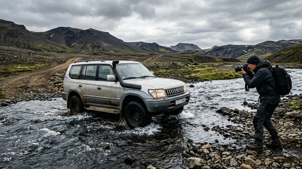
Navigating Iceland's interior requires a strict understanding of mountain road classifications, unbridged river crossing techniques, and offline navigation tools. This Iceland F-roads photography guide provides landscape photographers with the technical protocols, 4x4 vehicle selection criteria, and route planning essentials necessary to capture remote locations like Landmannalaugar, Kerlingarfjöll, and Askja safely.
Driving into the Icelandic Highlands (Hálendið) places photographers in one of Europe's most dramatic and unyielding environments. Expanding across vast volcanic zones, glacial outwash plains, and high-altitude geothermal fields, the interior offers raw compositional elements: stark obsidian deserts, turquoise crater lakes, and acid-green moss contrasting against black ash. However, translating these extraordinary visuals into a successful photographic expedition demands meticulous preparation. Operating off the Ring Road requires specialized driving skills, specialized insurance awareness, and reliable, offline-accessible location data.
This comprehensive guide details the practical realities of highland travel for photographers in 2026. From choosing the correct class of 4x4 rental and executing hydro-dynamically sound river crossings, to managing digital map layers without cell service and protecting delicate digital camera sensors from volcanic dust, these field protocols will keep your expedition safe, legal, and visually productive.
Understanding the Highlands: Essential Rules in This Iceland F-Roads Photography Guide
The letter "F" in front of an Icelandic road number stands for Fjallvegur, which translates directly to "mountain road." F-roads are unpaved, unmaintained mountain tracks that traverse rough gravel, exposed lava fields, loose scree, and unbridged river networks. Under Icelandic law, driving on any road designated with an "F"—as well as specific non-F mountain routes like the Kaldidalur valley (Road 550) or Kjölur (Road 35)—is strictly prohibited for standard two-wheel-drive vehicles and small, low-clearance crossovers.
Understanding environmental law is equally crucial for any photographer seeking raw compositions. Off-road driving (akstur utan vega) is strictly illegal across all of Iceland, carrying steep financial penalties enforced by police and park rangers, as documented by safety authorities at SafeTravel Iceland, alongside mandatory legal proceedings. In fragile high-altitude tundra, vehicle tires break the delicate moss crust (Racomitrium lanuginosum) and sub-arctic soil, creating ruts that persist for decades and cause severe wind erosion. You must keep all four wheels on designated, marked tracks at all times. If a track is blocked by snow or water, you cannot drive around the obstruction over untouched terrain; you must turn back or park in an established turnout and continue on foot.
Highland tracks operate on strict seasonal windows governed by snow melt, soil saturation, and roadbed preservation. The Icelandic Road and Coastal Administration (Vegagerðin) systematically closes mountain routes during the spring thawing period (váskall) to prevent heavy vehicles from destroying turned-to-mud roadbeds. Seasonal openings vary heavily based on winter snowpack and late-spring temperatures:
- Early-opening routes (Late May to Mid-June): Accessible lower highland tracks such as Road 35 (Kjölur) and F208 Northern section up to Landmannalaugar.
- Standard routes (Mid-June to Late June): Major interior corridors including F26 (Sprengisandur), F35 main pass, and F225 (Landmannaleið).
- Late-opening routes (Early July): High-altitude, river-heavy, or glacier-adjacent routes such as F206 (Laki), F910 (Öskjuleið/Askja), and F249 (Þórsmörk).
By late September or early October, first snowfall events begin closing these routes for the winter season. Operating on closed F-roads voids all rental insurance instantly and incurs heavy rescue fees, as emergency assistance in deep snow requires specialized search-and-rescue (ICE-SAR) deployment.
Selecting the Right 4x4 Rental for Highland Photography
Vehicle selection is the single most important tactical decision when planning a highland photography itinerary. Selecting a rental vehicle solely based on lower daily rates often leads to catastrophic mechanical damage or restricted access to key locations. For effective 4x4 rental iceland photography planning, rental vehicles fall into three primary tiers, each suited to specific terrain profiles.
Small, crossover 4x4s like the Suzuki Jimny or Dacia Duster are technically legal on basic F-roads, but their limited ground clearance (typically under 20 cm) and shallow air intake heights restrict them to smooth gravel tracks with shallow, slow-moving river crossings (such as F35 or F208 North). Mid-size models such as the Toyota Land Cruiser, Jeep Wrangler, or Toyota Hilux offer higher ground clearance, low-range transfer cases, and substantial water wading capabilities, making them suitable for the vast majority of highland photography destinations, including Landmannalaugar and Askja. Extreme routes like F249 to Þórsmörk or deep-interior tracks require custom modified Super Jeeps fitted with 38- to 44-inch flotation tires, raised air intakes (snorkels), and differential locks.
The table below summarizes vehicle classes, physical requirements, operational limits, and general suitability tiers for 2026 highland travel:
| Vehicle Class | Example Models | Ground Clearance & Wading Capability | Suitable Highland Routes | Terrain Tier |
|---|---|---|---|---|
| Compact 4x4 | Suzuki Jimny, Dacia Duster | 19–21 cm clearance / Shallow wading | F35 (Kjölur), F208 North (no rivers), F225 (shallow water) | Entry Highland |
| Mid-Size / Large SUV | Toyota Land Cruiser, Jeep Wrangler, Hilux | 23–28 cm clearance / Moderate-to-deep wading | F208 South, F26 (Sprengisandur), F88 / F910 (Askja), F206 (Laki) | Standard Highland |
| Modified Super Jeep | Custom Ford F-350 / Defender 38"+ tires | 35+ cm clearance / Deep water capabilities | F249 (Þórsmörk/Krossá), deep glaciated tracks, early-season snow | Extreme Highland |
Insurance coverage in Iceland requires careful scrutiny. Standard Collision Damage Waiver (CDW) and Super CDW policies strictly exclude undercarriage damage caused by rocks and gravel, as well as any water damage caused by river crossings. As outlined by SafeTravel Iceland, if you stall an engine inside a highland river or crack an oil pan on a submerged boulder, drivers are personally liable for engine replacement and off-road vehicle recovery costs, which can easily reach thousands or tens of thousands of dollars. Specialized add-ons like Sand and Ash Protection (SADP) and Gravel Protection (GP) are essential during dry, windy summer days when volcanic dust and high-speed stones can strip paint and pit windshield glass within minutes.
Mastering River Crossings and Rough Terrain with Heavy Gear
Unbridged river crossings represent the highest mechanical hazard in the Icelandic interior. Rivers in the Highlands are fed by glacial meltwater and mountain rain; their depths, flow rates, and riverbed profiles change continuously throughout the day. A river that was ankle-deep at 08:00 AM after a cold night can become a raging torrent by 17:00 PM as ambient temperatures melt glacial ice upstream.
Before driving into any river crossing, adhere strictly to field safety protocols recommended by emergency agencies such as SafeTravel Iceland:
- Stop and inspect on foot: Park the vehicle safely on the bank. Put on wading boots or sandals and probe the crossing on foot if depth or current speed is uncertain. As a primary safety rule, avoid entering water that flows above knee height or moves faster than a comfortable walking pace.
- Identify the path: Look for the widest part of the stream, as narrow sections are frequently deeper with stronger currents. Avoid driving directly downstream of large visible boulders where underwater drop-offs and large scour holes gather.
- Engage 4WD Low Range: Shift into four-wheel drive low (4L) and select first or second gear (or manual gear hold in automatic transmissions) before your tires enter the water. This ensures continuous engine torque and prevents automatic gear shifts mid-stream.
- Drive diagonally downstream: Enter the water slowly to build a modest bow wave in front of the vehicle bumper. Drive at a steady, walking-pace speed diagonally downstream along the flow line. Avoid driving straight upstream against a strong current or driving fast enough to force water over the hood into the engine air intake.
- Maintain steady momentum: Do not stop, change gears, or depress the clutch while in the middle of the river. Maintain constant throttle pressure until all four wheels are fully on solid dry ground.
Rough mountain tracks subject photographic equipment inside the vehicle to extreme vibration. Corrugated gravel ("washboard") roads can vibrate loose mounting screws, unseat internal lens alignment elements, or damage mechanical camera components over several hours of travel. Pack camera bodies and lenses inside heavy-duty foam-padded hard cases (such as Pelican or Nanuk cases) rather than soft backpacks. Secure these cases directly to the cargo floor using ratcheting tie-down straps. Hard cases sitting unsecured on leather seats can easily slide or break free during emergency braking maneuvers or sharp inclines.
Navigating Without Cell Service: Offline Waypoints in Your Iceland F-Roads Photography Guide
Cellular connectivity across the Icelandic interior drops off sharply outside the primary mountain passes. While major ring-road towns enjoy mobile network coverage, vast expanses of the central highlands have zero cell signal. Photographers relying on live web mapping applications, stream-on-demand directions, or active mobile browser searches will find themselves without map references or location details precisely when navigating complex mountain junctions.
To eliminate reliance on cellular towers, landscape photographers must use offline-capable mapping workflows. Formats such as KML, GPX, and GeoJSON store spatial data directly on your device's physical storage, housing exact coordinates, elevation contours, and geographic markers locally. Utilizing mobile vector mapping applications like Gaia GPS, Organic Maps, or OsmAnd allows you to view geographic location via native device satellite GPS chips without requiring active cellular data transfer.
When selecting spatial datasets for highland navigation, it is vital to distinguish between routing engines and static coordinate points. The spatial dataset files provided by Iceland Photo Map are curated waypoints. Your mapping app—Gaia GPS, OsmAnd, Organic Maps, or a dedicated Garmin unit—handles routing and display. The KML, GPX, and GeoJSON files live on your device, ensuring the waypoints work seamlessly with zero signal. Downloading offline map tiles (the visual background topography) is a separate step inside your chosen mapping app that you must execute while connected to Wi-Fi prior to entering the highlands.
Understanding what data files carry helps set realistic operational expectations in the field. The files carry seasonal and access notes rather than live conditions. Check official portals like vedur.is and road.is for real-time weather and road updates before disconnecting from internet access. Files purchased from Iceland Photo Map are delivered directly via email upon purchase. If a file does not load on your device, customer support is available within 30 days to resolve the issue or provide a full refund. Furthermore, the coordinates are published as an open CC-BY dataset; the curation, file formatting, and structured access notes are what provide value to traveling photographers.
To evaluate how coordinate datasets compare with traditional guidebooks or mobile applications, photographers can review a sourced comparison of Iceland photography guides on our site, which details where alternative physical books or specialized apps hold distinct advantages or tradeoffs.
Weather Monitoring and Road Closures: Safety Protocols for 2026
Highland weather is notoriously unstable. Rapid atmospheric changes can transform a clear morning into zero-visibility whiteout conditions, intense horizontal rain, or severe sandstorms within an hour. High-altitude passes frequently experience frost and ice even during mid-summer months.
To operate safely in 2026, photographers must check two authoritative government portals every morning before setting out:
- Road Conditions (road.is): Offers real-time reports from Vegagerðin on mountain road openings, closures, surface conditions, webcams, and river alerts. Never enter an F-road marked as Ófært (impassable) or Lokað (closed).
- Meteorological Forecasts (vedur.is): Provided by the Icelandic Meteorological Office (Veðurstofa Íslands). Pay critical attention to mountain wind speed forecasts (measured in meters per second, m/s) and wind gust warnings. Sustained high winds or strong gusts can make vehicle handling dangerous, tear open car doors, and send volcanic gravel flying with enough force to strip paint and shatter vehicle glass.
Before heading into remote interior sections like Askja or the Laki craters, submit an active travel plan with SafeTravel Iceland. This electronic notification system alerts local search and rescue teams if you fail to check in by your scheduled arrival time. Carrying a personal locator beacon (PLB) or satellite messenger (such as a Garmin InReach or ZOLEO) provides a critical communication channel when cellular networks are out of range.
If you encounter an unexpected highland sandstorm or volcanic dust blizzard, turn the vehicle to face directly into the wind to prevent car doors from catching the wind and buckling backward. Park clear of active track lines, turn on hazard lights, pull protective covers over optical glass, and wait for the storm front to pass.
Top Highland Photography Routes: From Kerlingarfjöll to Askja
Planning an efficient photography itinerary across the interior requires balancing transit distances, road technicality, and visual yields. Below are detailed operational profiles for three premier highland photography corridors.
1. Route F35 (Kjölur) and Kerlingarfjöll
The Kjölur route cuts north-south directly between two massive ice caps: Langjökull to the west and Hofsjökull to the east. Route 35 has been upgraded over recent years and no longer carries the formal "F" prefix, as all major river crossings along the primary corridor have been bridged. However, it remains a heavily corrugated, unpaved gravel track requiring a 4x4 for rental compliance and vehicle control.
Diverging off Route many onto Route F347 leads into the heart of the Kerlingarfjöll mountain range and the Hveradalir geothermal basin. Hveradalir is one of Iceland's most impressive geothermal landscapes, featuring boiling mud pools, steaming vents (fumaroles), and snowbanks contrasting against vivid orange rhyolite peaks. Photographic Strategy: Plan to shoot at Hveradalir during low-angle twilight or side-lit afternoon light when rising steam clouds pick up warm directional lighting. Use a wide-angle lens (16-35mm) to emphasize leading pathways through the steaming clay hills, and carry a circular polarizer to cut glare on wet volcanic clays.
2. Route F208 (Fjallabaksleið Nyrðri) and Landmannalaugar
Route F208 is the primary artery through the Fjallabak Nature Reserve, connecting the southern lowlands to Landmannalaugar. The route is divided into two distinct technical sections:
- F208 North: Unpaved but fully bridged track leading down from Sigalda. Accessible by compact 4x4s in good summer conditions.
- F208 South: A long, highly scenic, and challenging track crossing numerous unbridged streams and rivers between Landmannalaugar and the Ring Road near Vík. Requires a mid-size or large 4x4 with high ground clearance.
Landmannalaugar itself is famous for its multicolored rhyolite mountains, expansive black lava fields (Laugahraun), and natural geothermal bathing rivers.
Photographic Strategy: Hike up to the summit of Brennisteinsalda or Bláhnjúkur for elevated panoramic shots over the braided river beds and pastel-hued ridges. Mid-day light under partial cloud cover can showcase the vibrant greens, yellows, and reds in the mineral-rich hillsides, while late evening golden hour highlights mountain textures.
3. Route F88, F910, and the Askja Caldera
Traversing the northeastern interior to the Askja caldera represents a true deep-highland expedition. Route F88 branches south off the Ring Road, traversing vast lava deserts (Ódáðahraun) and requiring crossings of deep, swift rivers like the Lindaá and Grafarlandaá. Alternatively, Route F910 offers a rougher, highly volcanic approach across recent lava flows.
Askja is a massive 50-square-kilometer collapse caldera surrounded by the Dyngjufjöll mountains. Inside sits Lake Öskjuvatn and the smaller geothermal crater lake Víti, famous for its milky blue, sulfurous water.
Photographic Strategy: Capturing the scale of Víti crater inside the immense Askja caldera requires an ultra-wide lens (12-24mm) or multi-shot panoramic stitching. The stark contrast between black tephra sand, turquoise water, and lingering summer snow provides striking graphic compositions.
Field Preparation Checklist: Packing, Fuel, and Emergency Supplies
Operating self-sufficiently in remote regions requires carrying redundant gear, ample extra fuel, and dedicated emergency provisions. Fuel stations in the interior are virtually non-existent; the few pumps that do exist (such as at Hveravellir or Landmannalaugar) operate on automated card terminals that require a 4-digit chip-and-PIN credit or debit card.
Use this pre-departure checklist before leaving tarmac roads:
- Vehicle & Navigation Checklist:
- Full tank of fuel plus calculated return reserve (often re-fill at the last lowland gas station).
- Full-sized spare tire, hydraulic jack, wheel brace, and wooden board base (to support the jack on soft sand or gravel).
- Tire pressure gauge and 12V portable air compressor (to air down tires for soft sand and air back up for rocky tracks).
- Towed recovery strap (rated to at least 5 tons) and bow shackles.
- Pre-downloaded map tiles and coordinate waypoints stored inside your offline mapping application on a charged device. An Iceland highland photography map dataset loaded on your mobile phone ensures offline access to precise coordinates even without cellular service.
- Photographic Equipment Protection:
- Hard shell weather-sealed gear case strapped down inside the passenger cabin.
- Multiple rain covers for camera bodies and long lenses.
- Microfiber cloths (at least 10–15) stored in sealed plastic bags, alongside a rocket air blower to remove dry volcanic ash before wiping lenses.
- Lens cleaning solution to remove sticky mineral deposits from geothermal steam spray.
- Protective clear/UV filters mounted on all primary lenses to shield front elements from flying gravel and abrasive windblown sand.
- Emergency & Survival Gear:
- High-calorie non-perishable emergency food rations for 3 extra days.
- At least 5 liters of fresh drinking water per person per day.
- Sub-zero rated sleeping bag and thermal emergency bivvy sacks.
- Satellite communication device (Garmin InReach, SPOT, or PLB) and high-capacity USB power banks.
- Neoprene river-wading boots and heavy-duty waterproof outerwear.
Final Thoughts: Respecting the Wilderness While Pursuing the Shot
Highland landscape photography is a uniquely rewarding pursuit, offering access to dramatic, undisturbed volcanic geology and wild sub-arctic light. However, the preservation of these fragile landscapes rests on the decisions made by individual visiting photographers. Environmental protection and personal safety must often take precedence over capturing a photograph.
Always respect seasonal road closures, observe park ranger directives, stay strictly on designated tracks, and carry out all waste. By preparing thoroughly with capable 4x4 vehicles, verified safety protocols, official meteorological resources from vedur.is, and reliable offline mapping tools, you ensure that your journey into Iceland's interior is both visually productive and environmentally responsible.
Frequently Asked Questions
When do F-roads in Iceland typically open and close for the season?
Most F-roads open between early June and early July, depending on winter snow depth, spring thaw conditions, and roadbed drying rates. Lower, fully-bridged routes like Road 35 (Kjölur) often open by late May or early June, while deep interior routes like F206 (Laki) or F910 (Askja) frequently remain closed until late June or early July. Most highland tracks close for the winter by late September or early October following initial snowfalls. Daily status updates are published on road.is.
What type of 4x4 rental vehicle is legally required for driving on F-roads?
Icelandic law strictly requires a four-wheel-drive (4x4 or AWD) vehicle for driving on any designated F-road. While small 4x4 crossovers (like a Suzuki Jimny) are legally permitted on basic, well-maintained gravel F-roads, complex routes with unbridged river crossings (such as F208 South or F910) require mid-size or large 4x4 SUVs with higher ground clearance, high-mounted air intakes, and low-range gearbox options.
Are river crossings covered by car rental insurance in Iceland?
No. Standard Collision Damage Waiver (CDW) policies, Super CDW, and third-party credit card rental coverages almost universally exclude water damage caused by crossing rivers or driving into streams. Any damage to the engine, electrical systems, or undercarriage caused by water entering the air intake or riverbed impact is the full financial responsibility of the renter. Driver caution and proper hydro-dynamic crossing techniques are essential.
How do offline waypoint files help when photographing remote highland locations?
Because vast expanses of the Icelandic interior lack cellular coverage, live mapping websites and streaming navigation services cannot load map tiles or locate markers. Spatial files (such as GPX, KML, and GeoJSON) store exact latitude and longitude coordinates directly on your mobile device or GPS receiver. When imported into offline vector mapping applications, these waypoints allow you to locate precise photographic composition spots, parking pull-outs, and access tracks using your device's built-in GPS hardware without relying on cellular networks.
Ready to plan your highland photography route? Explore Iceland Photo Map to download curated waypoints for Iceland's highlands and map your 4x4 photography itinerary directly in your preferred offline navigation app.