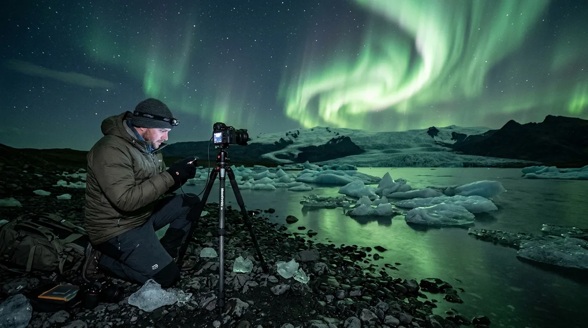
Capturing spectacular aurora borealis photography in Iceland requires pairing active geomagnetic displays with compelling foreground elements and pitch-black skies. Identifying top Northern Lights photo spots Iceland offers—from ice-choked glacial lagoons along the South Coast to solitary mountain peaks in the Snaefellsnes Peninsula—allows landscape photographers to elevate a simple green glow into a gallery-worthy masterpiece. Finding where to photograph the northern lights in iceland involves evaluating low light pollution, safe winter parking, physical terrain, and camera framing opportunities long before darkness falls.
Understanding Dark Skies and Foreground Elements in Aurora Photography
A photo of the aurora borealis shot straight up into the night sky often fails to capture the scale and atmosphere of the Arctic. Without a grounded anchor, green auroral rays lack context, scale, and spatial depth. Strong night compositions rely heavily on high-contrast foreground elements such as jagged sea stacks, reflective glacial pools, snow-covered basalt columns, and historic architectural landmarks. Water surfaces are particularly valuable during night shoots: still lagoons, calm sea coves, and river estuaries mirror the vibrant greens, purples, and deep reds above, effectively doubling the light output and color impact across your frame.
Dark sky quality is another crucial factor when planning aurora borealis photography iceland expeditions. Light pollution around urban centers like the Greater Reykjavík Capital Region can significantly obscure subtle night sky phenomena. While intense geomagnetic storms remain visible above city streetlights, faint auroral pillars and delicate purple curtain fringes are easily washed out by suburban infrastructure glow. Heading into rural regions like the Westfjords, East Iceland, or remote stretches of the South Coast dramatically reduces ambient illumination, exposing intricate atmospheric structures, sub-auroral red arcs (SARs), and the dense stellar backdrop of the Milky Way.
Thorough fieldwork planning demands reliable spatial and geographic data. Photographers planning night itineraries benefit from structured location guides that provide precise decimal coordinates, primary geographic categories, and recommended operational seasons so you can scout shooting vectors, horizon clearance, and light pollution angles before heading into the winter night.
Top Northern Lights Photo Spots Iceland: South Coast and Snaefellsnes
The southern and western coastal regions contain some of the best places for northern lights iceland provides, combining dramatic coastal features with accessible paved routes along the Ring Road (Route 1) and Highway 54.
Jökulsárlón Glacier Lagoon and Diamond Beach
Located on the southeastern edge of the island, Jökulsárlón Glacier Lagoon is widely considered a premier location for Northern Lights photo spots Iceland travellers prioritize. Calved icebergs from the Breiðamerkurjökull outlet glacier float silently in the deep tidal lagoon, reflecting green auroral bands across mirror-like water.
- Composition Strategy: Position your tripod low to the water's edge on the western shoreline, using static ice blocks jammed in the gravel as leading foreground elements. Ultra-wide focal lengths (14mm to 20mm) allow you to capture both the foreground ice detail and the sweeping arc of the northern sky.
- Diamond Beach Considerations: Just across the highway at the mouth of the tidal channel, icebergs wash ashore onto black volcanic sand. Shooting night exposures here requires constant vigilance regarding wave surges, rising tides, and shifting ice chunks that can pull camera gear into freezing sea brine.
Kirkjufell and Kirkjufellsfoss
Situated on the northern coast of the Snaefellsnes Peninsula, Kirkjufell ("Church Mountain") offers an iconic visual profile. When framing from the upper cascades of Kirkjufellsfoss waterfall, the mountain's sharp peak aligns under northern sky exposures.
- Composition Strategy: Cross the footbridge and setup on the lower shelf of the waterfall. Use a fast wide-angle prime to frame the cascading water in the bottom third of your image while the mountain peak balances the active aurora dancing overhead.
- Lighting Dynamics: Nearby Grundarfjörður town lights cast a soft ambient glow on the western flank of Kirkjufell, which can help illuminate mountain texture without artificial flash fill when balancing your white balance settings.
Búðakirkja Black Church
The pitch-black wooden chapel at Búðakirkja stands isolated against the vast lava fields of Hraunhavn on the southern Snaefellsnes coast. The stark contrast between the dark timber, light window frames, and glowing green skies makes this one of the most striking architectural targets in the region.
- Composition Strategy: Step back along the stone pathway to shoot with a medium-wide lens (such as 24mm or 35mm). This prevents vertical keystoning of the church spire while maintaining a balanced ratio between the dark architecture and sweeping sky display.
- Access Note: Winter parking is situated directly off the access spur. Photographers should stay strictly on gravel paths to avoid trampling delicate winter vegetation and moss beds nearby.
Remote Northern Lights Photo Spots Iceland: North and East Regions
Escaping coastal tourist corridors reveals exceptionally dark skies across North Iceland and the Eastfjords, where sub-Arctic latitude advantages grant extended dark hours during winter and shoulder months.
Aldeyjarfoss Waterfall
Tucked into the northern rim of the Highlands within the Bárðardalur valley, Aldeyjarfoss plunges into a wide basin framed by symmetrical, twisted basalt columns. Under an active auroral oval, the contrasts between dark basalt rock face, white glacial foam, and vibrant atmospheric light generate dramatic gallery-grade imagery.
Shooting Aldeyjarfoss at night involves serious logistical prep. Access requires driving along gravel route 842 and mountain tracks, which are strictly restricted to modified 4x4 vehicles during winter months. Spray from the plunging glacial river freezes upon contact with surrounding basalt columns and footpaths, creating severe black ice hazards near cliff drop-offs. Photographers must wear steel-spike microspikes on winter boots and keep tripods firmly anchored away from icy edges.
Goðafoss (Waterfall of the Gods)
Easily accessible via Route 1 between Akureyri and Lake Mývatn, Goðafoss curves in a broad horseshoe shape across the Skjálfandafljót river. Its expansive geometry offers distinct compositions from both eastern and western bank vantage points.
- East Bank Advantage: Provides elevated views over the main fall curtain, allowing wide-angle setups to capture the entire arc of the aurora spanning north to northeast.
- West Bank Advantage: Brings you closer to river level, where calm water pools in front of the lower rapids reflect auroral colors clearly during long exposures.
High-latitude locations across North Iceland experience deep night skies earlier in autumn compared to southern regions. During shoulder months like September and October, northern locations gain additional minutes of true astronomical darkness each night, granting extended windows for high-contrast night sky captures.
Essential Tools for Predicting Aurora Activity and Local Weather
Successful night photography relies on real-time atmospheric tracking rather than luck or arbitrary planetary indices. Knowing how to read local cloud layers and road safety portals determines whether you capture green skies or spend hours stranded in a mountain blizzard.
The primary authority for localized atmospheric forecasts is the official Icelandic Meteorological Office (Veðurstofa Íslands) aurora forecasting service. Evaluating this resource requires understanding how cloud layer overlays operate:
- Green Shading vs. White Space: On the Veðurstofa map, green areas indicate cloud cover, while clear sky zones are represented by white space. Selecting clear, unshaded pockets across your target destination is critical.
- Low, Mid, and High Altitude Cloud Layers: High clouds may allow bright auroral light to bleed through with moderate diffuse haze. Low-altitude clouds present solid, opaque barriers that entirely block overhead sky views, regardless of solar activity.
- Kp Index Realities: The geomagnetic Kp index measures global disturbance on a 0 to 9 scale, as reported by authorities such as the Icelandic Meteorological Office (Veðurstofa Íslands). However, local cloud cover always takes precedence over planetary indices. A modest Kp reading under cloudless, dark skies yields significantly better photos than a major solar storm hidden behind thick maritime fog.
Before leaving accommodation, cross-reference atmospheric charts with official road infrastructure portals. Real-time driving conditions, surface icing warnings, and mountain pass wind alerts are continuously updated by the Icelandic Road and Coastal Administration (Vegagerðin). During volatile sub-Arctic winter fronts, coastal highways can transition from dry asphalt to snow drifts very quickly.
When using spatial planning resources, remember that location datasets serve specific roles: files carry season and access notes, not live weather conditions. often consult vedur.is and road.is for current weather and road status prior to embarking on any night expedition.
Technical Camera Setup and Gear Management for Night Photography in Sub-Zero Weather
Executing sharp, noise-free night compositions under extreme freeze conditions requires strict technical controls and equipment protection routines.
Lens Selection and Focal Lengths
To capture fast-moving auroral ribbons without introducing blurred star trails, photographic setups require wide-angle lenses with fast maximum apertures:
- Aperture: Lenses with fast maximum apertures (between f/1.4 and f/2.8) are essential. They maximize light gathering on digital sensors, allowing shorter exposure times that keep dynamic auroral curtain structures crisp.
- Focal Length: Ultra-wide focal ranges (14mm to 20mm on full-frame sensors) excel at sweeping landscape scenes including foreground, horizon, and zenith sky. Fast wide primes deliver crisp corner-to-corner sharpness and minimal optical distortion compared to heavy zoom lenses.
Exposure Settings Matrix
Balancing shutter speed, sensor ISO sensitivity, and aperture setting depends directly on how fast the geomagnetic curtain is moving across the night sky:
| Aurora Intensity & Speed | Recommended Aperture | Exposure Time (Shutter Speed) | Base ISO Range | Technical Target |
|---|---|---|---|---|
| Faint / Static Arc (Quiet glow on northern horizon) | f/1.8 – f/2.8 | 8 to 15 seconds | ISO 1600 – 3200 | Maximizes signal-to-noise ratio; pinpoint stars; deep sky detail. |
| Active Moving Rays (Pillars shifting slowly overhead) | f/1.4 – f/2.0 | 3 to 6 seconds | ISO 3200 – 6400 | Freezes distinct vertical ray structures without smearing light. |
| Explosive Corona / Storm (Rapidly dancing magenta & green rays) | f/1.4 – f/1.8 | 0.5 to 2 seconds | ISO 6400 – 12800 | Captures ultra-fast wave dynamics; prevents overexposing green channel. |
Managing Cold Temperatures, Condensation, and Ice
Sub-zero winter conditions impact camera performance, lens glass clarity, and power supply systems:
- Lithium-Ion Power Loss: Cold temperatures slow chemical reactions inside camera batteries, rapidly dropping operating performance. Store spare batteries inside internal jacket pockets close to body heat, swapping them out as operating units cool down.
- Lens Condensation & Internal Fogging: Moving cold camera gear directly into heated vehicles or warm indoor spaces causes ambient moisture to condense on optical glass elements. Before stepping inside, seal your camera body and lenses tight inside airtight plastic bags, allowing the gear to warm up gradually so condensation forms on the bag rather than internal lens barrels.
- Front Element Icing: When photographing near roaring waterfalls like Goðafoss or coastal spray zones, moisture droplets hit freezing front lens elements and can turn to ice. USB-powered lens heater strips wrapped around outer lens barrels help maintain glass temperatures slightly above freezing.
Tripod Stabilization in Arctic High Winds
High winds along exposed black sand beaches and cliff edges can easily destabilize light camera setups. A swaying tripod ruins long exposures. Remove loose camera straps that catch the wind, extend thick upper leg sections first rather than thin lower extensions, and anchor your tripod weight hook using a heavy backpack resting on ground gravel.
Offline Waypoint Navigation for Safe Nighttime Fieldwork
Navigating pitch-black Icelandic backroads, unlit fjord turnoffs, and snow-covered coastal parking areas presents severe navigation challenges. Cellular network connectivity frequently drops in deep mountain valleys, narrow fjords, and high-plateau passes, rendering web-based streaming mapping services unreliable when you need them most.
Reliable field navigation depends on pre-loading standalone spatial data onto dedicated offline mapping software. Vector files like KML, GPX, and GeoJSON reside on your device, allowing waypoints to function without active cell reception. Downloading offline map base tiles is a crucial preparatory step within your mapping application before departing.
To ensure seamless routing, clarify your software setup: the vector files provide precise waypoint coordinates, while your choice of navigation app—such as Gaia GPS, OsmAnd, Organic Maps, or a Garmin unit—handles active route calculation. Loading exact latitude/longitude coordinates into your offline tool allows you to map driving approach vectors, mark safe winter parking turnouts away from soft snow drifts, and locate footpaths leading safely toward recommended viewing platforms.
When sourcing spatial assets for your journey, operational clarity and reliable data structuring are essential:
- Dataset Structure: Curated location points feature precise decimal coordinates, primary geographic classification, and recommended seasonal availability notes.
- Open Data Standard: Coordinates are shared under open data practices. Iceland Photo Map offers structured curation, formatted GPX/KML file variants, and winter access guidance.
- Delivery Format: Iceland Photo Map provides downloadable digital vector files delivered directly via email for instant field use.
- Simplified Access: Purchases do not require setting up complex accounts; files are emailed and accessible immediately upon order completion.
- Compatibility Support: Technical support ensures files work across major mapping apps and handheld GPS units.
- Market Context: Photographers can compare Iceland Photo Map with other planning guides transparently; view our detailed guide comparison at /iceland-photography-guides-compared for a balanced breakdown of features and coverage.
- Review Practices: Iceland Photo Map focuses purely on objective spatial data and verified field attributes without using artificial review widgets or rating overlays.
- Future Development Pipeline: Iceland Co-Pilot is in development (Android first) and will be included free with Iceland Photo Map purchases upon release—it is not sold separately and has no pre-order tier.
Safety and Etiquette when Photographing the Night Sky in Iceland
Shooting night sky landscapes alongside fellow photographers demands strict outdoor ethics, safety awareness, and environmental conservation practices.
Headlamp and Red-Light Etiquette
White light beams from high-lumen headlamps disrupt human night-vision adaptation (which can take up to twenty minutes to recover fully) and ruin long exposures on neighboring cameras.
- Switch headlamps to red-LED night mode before entering active shooting locations.
- Keep light beams angled strictly toward the ground at your feet rather than sweeping across open water, landscape horizons, or adjacent photography setups.
- If bright white illumination is briefly required to check camera settings, shield light spill using your jacket or gloved hands.
Road Safety and Off-Road Driving Prohibitions
Parking safely is a critical winter concern across Iceland. Official travel guidance from SafeTravel Iceland emphasizes that stopping or parking directly on paved travel lanes or narrow highway shoulders is extremely dangerous and strictly prohibited. Highway shoulders along Route 1 are often narrow, steep, and bordered by soft snowdrifts. Always pull entirely into designated gravel turnouts, official scenic viewpoints, or marked parking areas.
Driving off established roads or marked tracks onto fragile volcanic moss is illegal throughout Iceland and carries severe financial penalties. Arctic moss takes decades to recover from tire crush damage. Off-road vehicle tracks carve deep rut scars into fragile ecosystems, causing long-term soil erosion across vulnerable sub-polar landscapes.
Storm Monitoring and Emergency Alerts
Before traveling to remote night photography locations, always log your planned route, expected return times, and vehicle details with safety services via SafeTravel Iceland. Check for active blizzard warnings, avalanche advisories, and sudden wind alerts that could impact your return journey.
Frequently Asked Questions
What month is best for photographing the Northern Lights in Iceland?
The optimal window for aurora photography extends from late September through late March, when night skies provide full darkness. The shoulder months of September, October, March, and April offer milder weather, easier road access, and unfrozen water bodies ideal for ground reflections. Core winter months provide maximum hours of night darkness, though travelers must navigate winter storms and icy road conditions.
Do I need a 4x4 vehicle to reach Northern Lights photo spots in winter?
While major photography locations along Route 1 and the Snaefellsnes Peninsula (such as Jökulsárlón, Kirkjufell, and Búðakirkja) can be reached in a standard vehicle during clear weather, renting a studded-tire 4x4 vehicle is strongly recommended during winter months. As advised by the Icelandic Road and Coastal Administration (Vegagerðin), a 4x4 provides vital traction, ground clearance, and directional stability across black ice, packed snow, and slush on unlit rural access roads.
How do I load waypoint coordinates onto my offline navigation app?
After acquiring vector spatial files (such as GPX or KML formats), transfer them to your mobile device via email, cloud download, or direct transfer. Open your preferred offline navigation app—such as Gaia GPS, OsmAnd, Organic Maps, or a standalone Garmin device—and select the "Import" or "Open File" option to add the waypoints. Ensure you also download offline map base tiles for your target region within the app while connected to Wi-Fi prior to field departure.
Can I view real-time aurora forecasts directly inside my offline mapping app?
No. Offline mapping applications are designed to store static geographic coordinates, topography contours, and route vectors without cellular connection. Live atmospheric data—including active cloud coverage layers, geomagnetic updates, and real-time road conditions—must be checked separately through live online services like Veðurstofa Íslands and Vegagerðin prior to heading into areas without cellular service.
Download curated GPX and KML offline waypoints for Iceland's top photogenic spots directly to your mapping app to ensure reliable night navigation without cellular signal.