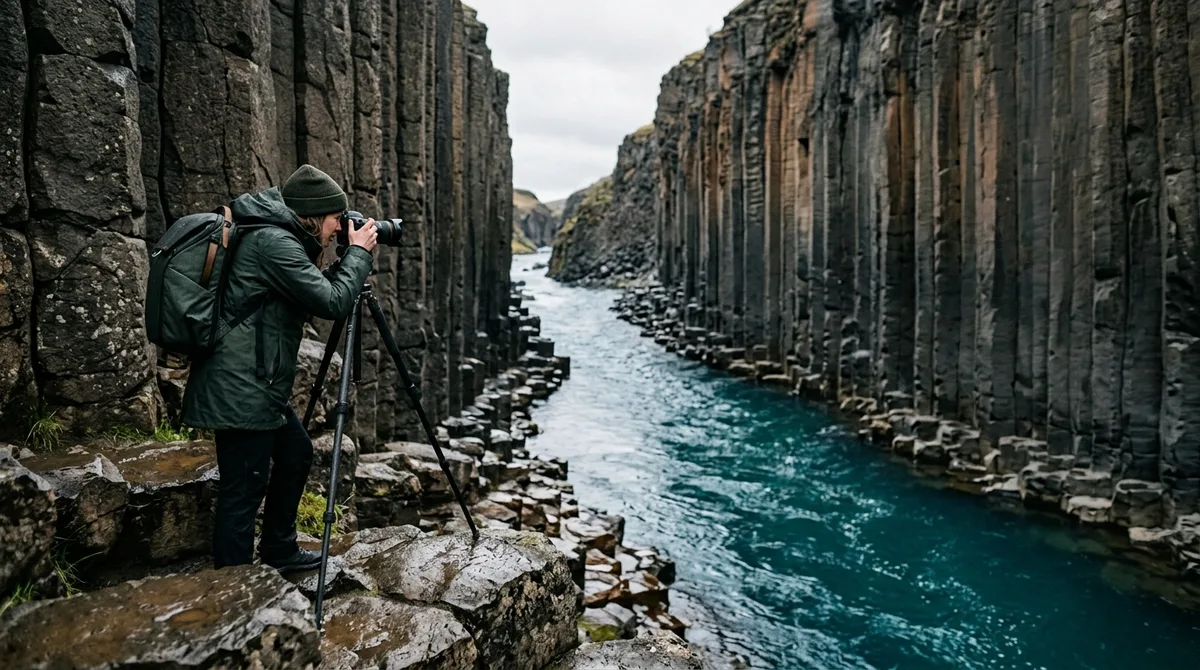
Capturing the towering columnar basalt walls and glacial waters of Stuðlagil requires timing your shoot around seasonal river colors, water levels, and canyon light angles. This Studlagil Canyon photography guide gives you exact access logistics, compositional strategies, lens recommendations, and lighting windows so you can capture East Iceland's most striking geological formation at its absolute best.
Located in the Jökuldalur valley in East Iceland, Stuðlagil (also spelled Stuðlagil) features one of the highest concentrations of columnar basalt in the world. Yet photographing it successfully is not as simple as showing up with a wide-angle lens. River conditions dictate whether the water runs vibrant turquoise or silt-heavy brown, while the canyon's deep, narrow profile creates severe dynamic range challenges that demand precise planning.
Geographic Overview: Why Stuðlagil Demands Precise Seasonal Planning
For centuries, Stuðlagil remained largely hidden beneath the turbulent, sediment-rich waters of the Jökulsá á Dal (also known as Jökulsá á Brú), one of Iceland's most powerful glacial rivers. The canyon's modern visual appearance is the direct result of the Kárahnjúkar Hydroelectric Project completed in the late 2000s. By diverting the bulk of the glacial river flow through tunnels into the Hálslón Reservoir, the water level dropped by dozens of meters, revealing soaring, hexagonal basalt columns rising directly out of the riverbed. Source: En Wikipedia source.
- Late Spring to Mid-Summer (June to Early August): The river is fed primarily by clean spring water and tributary runoff rather than direct glacial silt. During these weeks, the water typically presents a vivid turquoise or deep emerald green hue, providing the iconic color contrast against dark, rust-flecked basalt.
- When this spillover occurs, the river level rises rapidly and turns into a murky, brown-grey glacial torrent, submerging lower basalt shelves and eliminating turquoise reflections.
- Autumn and Winter (October to April): Water levels drop significantly, often returning to a clear, deep blue or teal tint before freezing along the margins. However, winter brings heavy snowdrifts, iced basalt shelves, and limited daylight, making East Iceland access far more demanding.
Tracking water conditions before your journey is critical.
East vs. West Bank: Selecting the Best Studlagil Canyon Photo Spots
There is no footbridge across the river inside the canyon itself, meaning you must commit to one side per visit or allocate time to drive around.
| Decision Criteria | West Bank (Grund Farm) | East Bank (Klaustursel Farm) |
|---|---|---|
| Access Type | Metal viewing platforms and steep staircase | Hike to natural riverbed and basalt shelves |
| Physical Effort | Low (5-10 minute walk from main lot) | The route follows an easy to moderate gravel trail. |
| Water-Level Access | None (Strictly overhead/elevated perspectives) | Direct access down onto dry basalt columns |
| Best Photographic Focus | Broad panoramic canyon overviews, geometric patterns from above | Human-scale framing, dramatic vertical low-angle shots, Stuðlafoss waterfall |
| Crowd Congestion | High turnover, tourist viewing platforms | Dispersed along trail and riverbed shelves |
West Bank: Elevated Perspectives from Grund
The West Bank, accessed via the farm at Grund, provides constructed infrastructure including parking, restrooms, a café, and wooden viewing platforms perched high on the canyon rim. A metallic staircase descends toward the gorge, offering a secure view looking straight down the corridor of basalt columns.
While the West Bank offers clean overviews of the canyon's geological curve, it does not permit access down to the water. Photographers aiming for intimate water-level reflections or dramatic upward-facing wide-angle compositions will find the barriers limiting. However, it remains an efficient location for aerial drone launches and high-angle telephoto compression shots highlighting the horizontal layering of basalt joints on the opposite wall.
East Bank: The Definitive Route for Landscape Photographers
The East Bank, accessed via Klaustursel, is where virtually all iconic studlagil canyon photo spots are found. From this side, a gravel trail leads south along the canyon rim before descending gently into the gorge, allowing photographers to walk directly out onto the hexagonal basalt formations along the river's edge.
Key East Bank vantage points include:
- The Basalt Beach Shelf: A flat basalt platform near the southern end of the gorge where the columns tilt at dynamic 45-degree angles, creating natural leading lines into the turquoise water.
- The Narrow Chokepoint: A section where basalt walls on both banks pinch inward, compressing the river current and providing perfect symmetry for vertical focal lengths.
- Stuðlafoss Waterfall: Located approximately 2 kilometers into the hike from the Klaustursel bridge, this distinct waterfall cascades over a tall wall of dark columnar basalt. It serves as an exceptional secondary shoot location along the trail, best framed with an ultra-wide lens or a mid-range zoom focusing on the tumbling white water against basalt geometry. Explore our guide to Iceland waterfall photography to see how Stuðlafoss compares with other columnar falls across the country.
How to Get to Studlagil Canyon: Driving Routes, Parking Areas, and Trail Times
Knowing how to get to studlagil canyon efficiently saves critical shooting light, especially when driving from regional hubs like Egilsstaðir or Akureyri.
Driving Directions from Route 1
Stuðlagil is situated in the upper Jökuldalur valley. From Route 1 (the Ring Road):
- Turn onto Route 923 (Jökuldalsvegur), located west of Egilsstaðir and east of Möðrudalur.
- For the West Bank (Grund): Follow Route 923 south on the paved and hard-packed gravel road for approximately 19 kilometers until you reach the marked Grund parking area on your left.
- For the East Bank (Klaustursel) : Drive approximately 14 kilometers down Route 923 until you see the sign for Klaustursel.
Before driving, verify current travel conditions via the official Icelandic Road and Coastal Administration (Vegagerðin / road.is) portal, as interior gravel roads in the East can develop severe washboarding or icy ruts outside the summer months.
East Bank Parking and Trail Breakdown
There are two primary parking areas on the East Bank:
- Parkplatz 1 (Klaustursel Bridge): The lower parking lot immediately after crossing the single-lane bridge. Parking here adds roughly 2 kilometers each way to your hike (totaling ~10 km round trip).
- Parkplatz 2 (Hiker Lot / Kárahnjúkar track): Located approximately 2 kilometers further south along a narrow, unpaved track past the bridge. During summer, standard 2WD vehicles can navigate this track with care, though high-clearance vehicles are recommended after heavy rainfall. Parking here reduces the hike to approximately 5 kilometers round-trip (about 45–60 minutes walking each way).
The hike follows a relatively flat, well-trodden gravel path passing Stuðlafoss. The final 200 meters require scrambling down a steep, rocky dirt path with ropes installed for stabilization. Take extreme caution when descending with heavy camera packs, as wet clay and loose scree make this section hazardous.
A Studlagil Canyon Photography Guide to Natural Light and Golden Hour Windows
The canyon runs roughly south-southeast to north-northwest, with walls towering up to 30 meters above the riverbed. This deep orientation creates severe lighting constraints depending on the time of day.
The Midday Dynamic Range Trap
Shooting Stuðlagil under direct midday sun (11:00 AM to 3:00 PM) results in harsh, unmanageable dynamic range. Direct overhead sunlight illuminates the silt-free water brilliantly, but it casts intense, pitch-black shadows across the western basalt columns while blowing out specular highlights on wet rock surfaces. If you must shoot during midday, bracket your exposures across 3 to 5 frames spaced at 1 or 2 EV increments to preserve shadow detail in the basalt crevices.
Morning and Late Afternoon Illumination Windows
The optimal lighting occurs when the sun sits low enough to diffuse light softly into the gorge without direct line-of-sight exposure creating split lighting. Early morning light (between 6:00 AM and 8:30 AM in summer) illuminates the upper rim of the eastern basalt columns while casting a soft, ambient glow into the riverbed. This balanced light preserves the saturated turquoise hues of the water without overwhelming your camera sensor's highlight limits.
Midnight Sun Tactics (June and July)
During the Arctic summer, shooting between 11:00 PM and 3:00 AM provides two massive photographic advantages:
- Zero Crowd Contamination: Stuðlagil has become one of Iceland's most frequented attractions. Visiting under the midnight sun ensures you can frame wide compositions without tourists standing on prominent basalt pedestals.
- Diffused Polar Glow: The perpetual twilight acts as a massive softbox, bathing the dark basalt in cool ambient light while maintaining rich tonal gradation across the river rapids.
Compositional Frameworks: Hexagons, Leading Lines, and Human Scale
Stuðlagil's unique geometry rewards disciplined, structural compositions rather than casual snapshot framing.
1. Repetition and Geometric Patterns: Basalt columns form when thick basaltic lava cools slowly and contracts vertically, creating hexagonal and pentagonal cooling joints. Use a 24-70mm or 70-200mm focal length to isolate sections of the wall where columns bend and twist under tectonic stress. Focus on the interlocking horizontal joints (cross-fractures) running across the vertical pillars to build compelling abstract textures.
2. The S-Curve River Leading Line: Position your tripod on the elevated basalt shelves on the East Bank looking north down the gorge. Position the bend of the river in the lower third of your frame, using the turquoise water to guide the viewer's eye through the frame toward the distant canyon exit.
3. Establishing Human Scale: The canyon walls are massive, but without a reference point, wide-angle photographs often flatten the perspective. Safely position a human subject (wearing high-contrast red, yellow, or orange outerwear) on one of the stable lower basalt shelves across the river or along the trail. Ensure your aperture is set to at least f/8 or f/11 to maintain crisp focus across both the subject and the rear basalt wall.
4. Long Exposure Water Smoothing: While the current in Stuðlagil is relatively swift, it contains minor whirlpools and foam lines. Using a 3-stop or 6-stop Neutral Density (ND) filter with an exposure time between 2 and 8 seconds transforms turbulent whitewater into silky turquoise streaks while keeping every basalt pillar razor-sharp. often anchor your tripod firmly; strong gusts frequently channel through the narrow canyon corridor.
Studlagil Canyon Drone Photography: Regulations and Aerial Perspectives
Capturing studlagil canyon drone photography reveals geometric patterns invisible from ground level, but operating an unmanned aircraft inside the gorge introduces serious technical and environmental challenges.
All drone operations in Iceland must comply with regulations enforced by the Icelandic Transport Authority (Samgöngustofa). Pilots must register their drones, display operator IDs, maintain direct visual line of sight (VLOS), and remain below maximum altitude ceilings (120 meters above ground level). Furthermore, local landowners at both Grund and Klaustursel may post seasonal signage regarding takeoff points, particularly during bird nesting periods in spring and early summer when fulmars and pink-footed geese nest along canyon ledges.
When piloting inside the canyon, account for these critical operational hazards:
- Magnetic Compass Interference: The massive concentration of basalt contains high levels of iron and magnetite. Calibrating your drone's compass on basalt rock or taking off directly from column shelves often causes compass errors and unexpected flyaways. often hand-launch or launch from a clean wooden or canvas pad away from dense rock surfaces.
- GPS Signal Occlusion: Descending deep between the 30-meter vertical canyon walls blocks satellite line-of-sight. Drones frequently drop into ATTI (Attitude) mode when flying low over the water. Be prepared for manual throttle and drift correction against canyon drafts.
- Wind-Tunnel Turbulence: The gorge acts as a natural venturi tube. Calm conditions on the rim can transition into violent 30-knot downdrafts inside the slot. Monitor your drone's battery consumption closely, as fighting upstream headwinds rapidly drains cell voltage.
For top-down compositions, position your camera at a 90-degree pitch looking directly down at the boundary where the turquoise current meets the perpendicular basalt prisms. This birds-eye perspective highlights the hexagonal mosaic structure of the column tops beneath shallow water.
Recommended Camera Kit, Lens Choices, and Wet-Rock Safety
Photographing Stuðlagil requires equipment suited for high dynamic range, moisture, and rugged terrain.
Lens Recommendations
- Ultra-Wide Zoom (14-24mm or 16-35mm f/2.8 or f/4): Essential for East Bank riverbed compositions where the basalt columns rise directly overhead. At 14mm to 16mm, you can capture the entire height of the canyon wall while maintaining the river in the foreground.
- Standard Zoom (24-70mm f/2.8 or f/4): The most versatile walkaround lens for Stuðlagil. Ideal for framing S-curves, isolating balanced column clusters, and shooting Stuðlafoss along the trail.
- Telephoto Zoom (70-200mm f/4 or f/2.8): Crucial for compressing wall textures from the West Bank viewing platform or isolating the geometric fractures in distant basalt faces across the river. Compare similar volcanic formations with our Aldeyjarfoss photography guide, where telephoto compression plays an equally vital role.
Essential Filters and Field Accessories
A Circular Polarizer (CPL) is mandatory for Stuðlagil. Wet basalt reflects blinding white sky light, washing out dark volcanic tones and obscuring the hexagonal column edges. Rotating a CPL cuts surface glare from the rock faces and eliminates water reflections, revealing the vibrant turquoise tones beneath the river surface. Pack a sturdy carbon-fiber tripod and microfiber lens cloths; spray from river rapids and waterfall mist easily settles on front elements.
Footwear and Cold-Weather Safety
Basalt rock becomes exceptionally slick when coated in wet river silt or algae. Standard running shoes or smooth-soled boots pose a severe slip hazard on the sloped East Bank shelves. Wear rigid hiking boots with deep Vibram lugs. During shoulder seasons (May, September, October), carry microspikes in your daypack to navigate icy patches on the access descent. Keep spare camera batteries in an internal coat pocket; cold valley temperatures accelerate battery drain.
Integrating Stuðlagil into an East Iceland Photography Itinerary
Stuðlagil Canyon pairs naturally with other East Iceland highlights along the Ring Road corridor. When building your route, allocate at least 3 to 4 hours for the East Bank excursion (including driving, hiking, and shooting) to avoid rushing your compositions.
Recommended nearby photography pairings include:
- Rjúkandi Waterfall: Located right off Route 1 in Jökuldalur, just 25 minutes north of the Route 923 turnoff. A convenient two-tier waterfall shoot to capture early morning soft light before heading to Stuðlagil.
- Hengifoss and Litlanesfoss: Situated south of Egilsstaðir along Lake Lagarfljót. Litlanesfoss features striking vertical basalt columns similar to Stuðlagil, while Hengifoss showcases distinctive red clay strata layers between basalt tiers.
- Seyðisfjörður: A dramatic fjord drive over the Fjarðarheiði mountain pass, offering misty mountain tarns, cascading waterfalls (Gufufoss), and the iconic blue church.
When organizing multi-day routes across the Eastfjords, having your waypoints configured before leaving main transit corridors prevents wasted driving time in areas with sparse mobile data. You can structure your regional route using a dedicated Iceland landscape photography map to link hidden canyon viewpoints with primary Ring Road landmarks.
Frequently Asked Questions
When is the water in Stuðlagil Canyon turquoise instead of brown?
The river is typically turquoise from June through early August, when flow consists primarily of clear spring water and minor mountain runoff. Between mid-August and late September, the upstream Hálslón Reservoir usually reaches capacity and overflows into the canyon, turning the river into a murky, silt-laden brown or grey torrent until autumn runoff subsides.
Which bank of Stuðlagil Canyon is better for photography?
The East Bank (accessed via Klaustursel) is significantly better for dedicated landscape photography because it allows you to hike directly down to the riverbed and basalt shelves for dynamic, low-angle compositions. The West Bank (Grund) provides elevated viewing platforms and stairs suitable for quick overviews and high-angle panoramas, but it does not offer water-level access.
Can I fly a drone at Stuðlagil Canyon in 2026?
Drone flight is generally permitted under standard Icelandic Transport Authority (Samgöngustofa) Open Category regulations (registration, pilot competency, maximum 120m AGL, VLOS). However, pilots must observe local landowner notices at Grund and Klaustursel, maintain distance from nesting birds during spring/early summer, and watch for magnetic compass errors caused by the high iron content in the basalt columns.
How long does the hike take on the East Bank of Stuðlagil Canyon?
From the closer hiker parking lot (Parkplatz 2, past the bridge), the hike is approximately 5 kilometers (3.1 miles) round trip and takes 45 to 60 minutes in each direction along a flat gravel path. If you park at the primary bridge lot (Parkplatz 1), add an extra 2 kilometers each way (roughly 30 additional minutes). Allow at least 1 to 2 hours at the canyon for shooting.
Download curated GPS waypoint files for Stuðlagil Canyon and East Iceland's top landscape locations to load directly into your favorite offline mapping app. If you use Gaia GPS on your mobile device, follow our step-by-step tutorial on how to import KML and GPX files into Gaia GPS so you can navigate directly to precise parking areas, trailhead paths, and riverside photo spots without relying on spotty cellular coverage.